Let me begin by pointing out the qualitative difference between a tourist and tour-ism. A real tourist is well-informed about what she wants to see and what he wants to do. Modern tour-ism is an industrial system organized to maximize profits for airlines, hotels, national parks and service businesses by co-opting a person’s normal curiosity and then herding them into an artificial experience, too often at the lowest common denominator, for a high price. Industrial tourism, as critic Edward Abbey pointed out, separates the tourist from what he originally came to see by inserting a commercial veil that dilutes the experience the traveler hoped to have.
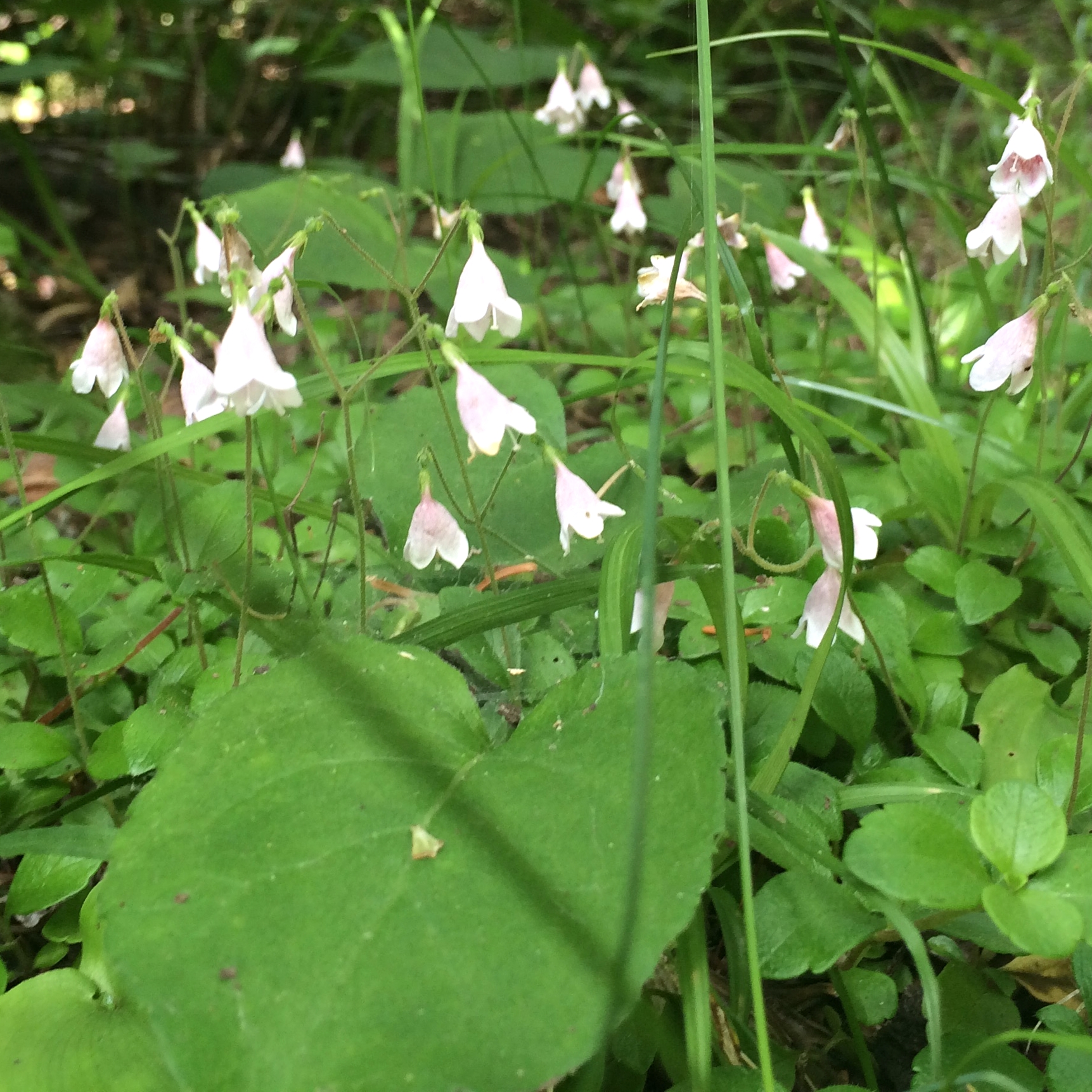
Twin flower
A true tourist doesn’t expect guarantees of satisfaction from his experience. Traveling is a risk and satisfaction depends on the traveler’s personal resources, her encounters with people she doesn’t know and his capacity to notice new and different things in the places and people he meets. Travel is a state of mined and you don’t have to go to distant countries and continents to be a tourist. No! You can be a tourist, even an explorer, in your own yard. Emily Dickenson roamed the world from her garden and Henry David Thoreau discovered the world from his cottage on Walden Pond.
Glacial groove
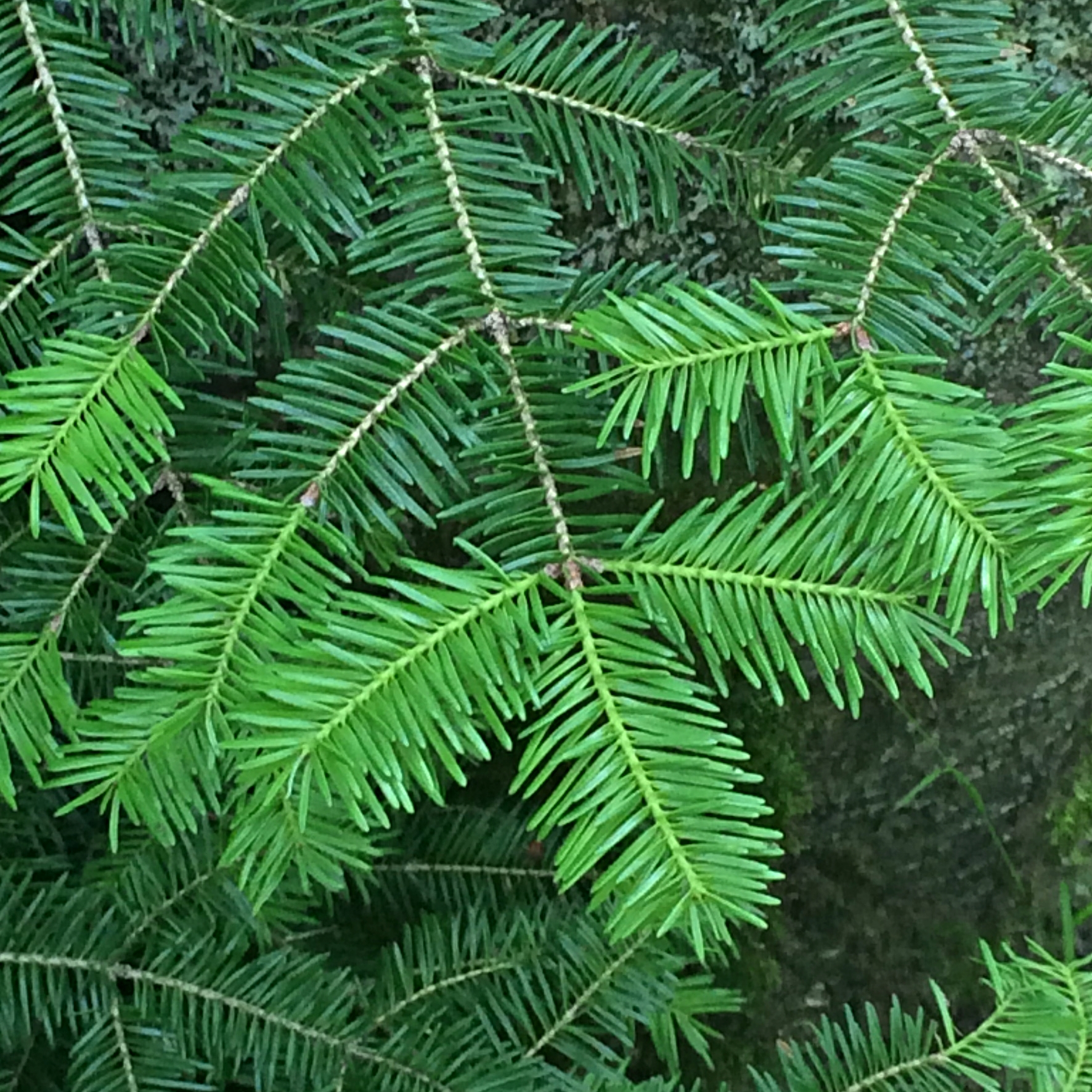
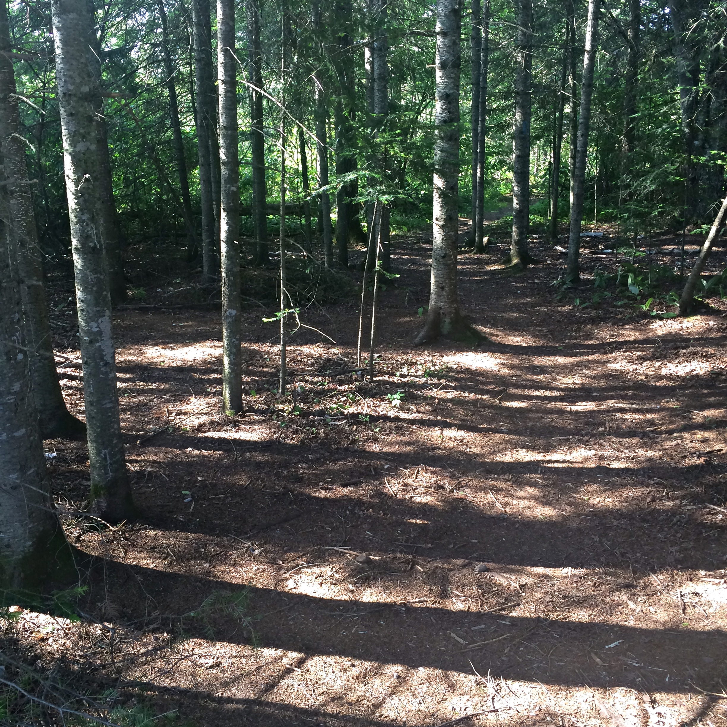
I often travel to distant places but today I was a tourist in a familiar place as I climbed 500 feet to the crest of a barren ridge overlooking Lake Superior. Today I looked at the route with the eyes of a tourist and saw anew how the afternoon light slanted through the trunks of spruce trees. On the trail, I stooped to admire the tiny blossoms of the twinflower, noted the two-toned green of new fir needles, the tough three-toothed cinquefoil growing in the cracks of a granite knob, and the groove in a granite knob left by a retreating glacier. To be a tourist is to be mindful of the moment, to take nothing for granted, to humbly suspend one’s ordinary assumptions and expectations of the familiar in order to see the extraordinary world in front of him. For me, this keeps the world perpetually new.
Afternoon light in spruce
Dreaming, learning, and then executing one’s plan of travel is the true joy of being a tourist. My daughter and I read up on Utah’s canyon country and then hiked for days in Arches, Natural Bridges, Canyonlands, and Mesa Verde national parks without a guide or outfitter. Our most important equipment consisted of open minds to we could see what was before us. I travel this way in Mexico. In the company of a Mexican friend, we rode rural taxis through the mountains to attend patronal festivals, visit indigenous pueblos, and share coffee with her friends. We didn’t have planners, clerks, guides, or tour buses to get in our way.
Our experiences weren’t fabricated according to predetermined metrics of customer satisfaction; they occurred spontaneously out of curiosity, mindful observation and personal interactions. So, go on tour, close by or far away, keep your mind clear, your eyes open, and you will be your own best guide.
Have you considered the advantages of traveling slowly and depending on the kindness of strangers? That’s why I like to walk. It’s my favorite way to go from one place to another when time allows. The quality of travel varies with the mode. By going on foot I move at a pace where I can see everything around me and take the time to experience the country I am moving through and the people I’m traveling with. What’s the rush?
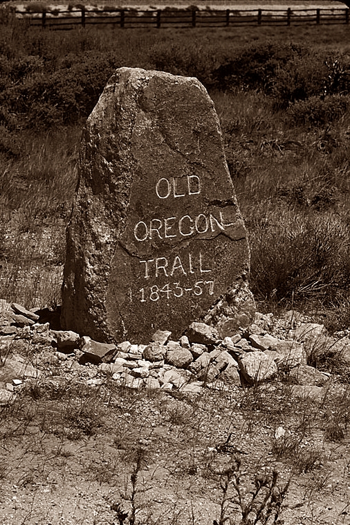
Setting out on the Oregon Trail
I came upon the pleasures of slow travel nearly 40 years ago when a friend and I hiked for 650 miles across the high plains of Nebraska, Wyoming, and Idaho. For nearly two months, we lived out of our packs as we tramped along America’s first superhighway–the wagon road known as the Oregon Trail.
The seed of this idea sprouted one sunny August afternoon near South Pass, Wyoming. I stopped the car at a historical marker for “The Parting of the Ways”. Behind the sign, two sets of ruts diverge in the waist-high sagebrush; one set aimed at the California goldfields, the other pointed to Oregon’s Willamette Valley. For many a westerner, a moment of decision; for me, an inspiration.
I walked along the Oregon-bound ruts for half a mile until I couldn’t see the car. Then I stared far west. What will I see if I keep walking? The question nudged me for two years until Geoff and I hoisted our backpacks at Scotts Bluff National Monument, Nebraska, and set out in dust storm to retrace the longest, undeveloped stretch of the Oregon Trail across open range until they vanished asphalt roads and barley fields in eastern Idaho.
Our simple maps, scaled at two miles to the inch, gave few details about what lay ahead. We didn’t have a watch, and we left behind such comforts as air mattresses and extra clothes. The best equipment in our kit were our personalities–we were each the other’s alter ego, the missing piece, the traits that made us greater than the sum of our parts. It worked–most of the time.
The Trail was never a single set of ruts but a broad corridor and we followed dirt farm roads for the first few days through the irrigated corn fields of the North Platte River Valley. Each day had its pattern: Rising at dawn, eating oatmeal and stewed fruit, hiking until midday, then a making a meal of fry bread and soup, napping for several hours in the shade of riverbank cottonwoods before taking to the Trail and walking in the low evening light of summer.
Morning glory and cactus.
Walking opens opportunities to notice the things that are invisible from a car going 70 miles per hour–the things that define a place. At 70 mph, Wyoming looks uninviting, a blur of gray sagebrush and glaring sunlight. At three miles per hour, the details are visible: the intense orange of globe mallow blossoms, smooth, white prickly poppies, and sky-blue flax. On foot, we moved to the rhythmic crunch of footfalls on the gravel; felt the sun’s reflected heat seeping through our boots; watched vultures wheeling in silent gyres like bits of black paper in the wide sky and over our shoulder, we watched afternoon thunderclouds atop Laramie Peak drift toward us.
Weather was our intimate companion, and the summery copulation of temperature and humidity produced sweat, thirst, and fatigue. Wind was a fickle friend, one day it’s a cooling breeze that wards off sweating but the next day it’s a dusty blast from an oven. Evening was usually the best of times, when the wind lay down for the night, cooler air flowed from the mountains, crickets sang, and we came out of mental hibernation and talked to each other.
Our daily thunderstorm.
Although we saw very few people in seven weeks, we didn’t travel alone. The backs of our simple maps held typed excerpts from the journals of those who crossed the Trail a century before us . Explorer Robert Stuart (1813), mountain man Jim Clyman (1829), Lt. John C. Fremont (1843), humorist Mark Twain (1862) and many ‘forty-niners guided, advised and entertained us daily.
Many times, when we rested beneath a tree, or along a dry creek, we read their words and compared what we saw with their description of the place. In 1977, the big energy boom hadn’t yet disturbed too much of the area and what we saw largely matched the view of the pioneers. We lived in a time warp. Thank God!
We planned to be completely self-sufficient but the kindness of strangers was always a bonus. The dust storm died at the end of the first afternoon, the bluffs glowed in the red sunset as we asked for water at a farmhouse. The farmer turned on a hose and then asked what were we doing and why were we doing it. “Wish you’d come sooner. We would of like to have you eat with us.” Before we left, his wife gave us a batch of peanut butter-oatmeal cookies. So began our travel with the kindness of strangers.
Geoff and I started the trip bickering over the proper walking pace. He wanted to make three miles an hour for seven hours a day. I argued for a two miles an hour for 10 hours a day because I knew his pace wasn’t possible with heavy packs. I said okay figuring experience would slow him to my pace. It did, in the end, but not until he raised blisters the size of silver dollars and I bruised my Achilles tendon.
“You want to see a doctor?” Geoff asked, massaging my swollen ankle.
“No! He’ll tell me to take aspirin and stay off my feet,” I said, popping a couple Tylenol. “Let’s find a place to lay over a couple days. If it doesn’t get worse, it’ll get better.”
At dusk, a farmer let us camp in a vacant pasture that had two ponds stocked with bass. I thought we’d died and gone to heaven. For two days, we rested, swam often, and ate our fill of fresh fish we caught using my fly-rod and grasshoppers.
Historical markers, landmarks, and graves mark nearly every few miles of the Oregon Trail. Some sites are off the highway, but some of the best aren’t easy to find and a few aren’t marked at all – that’s the draws.
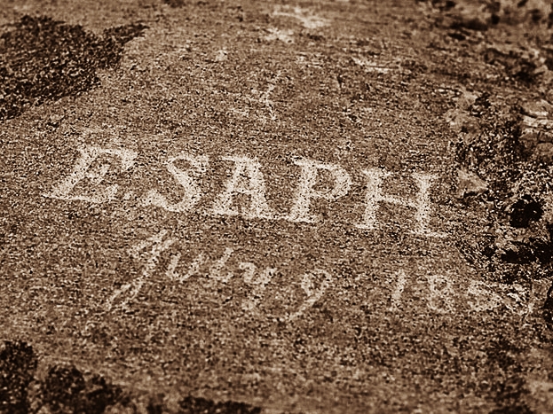
A name for posterity.
We usually stopped briefly at the well-developed tourist attractions, like Ft. Laramie National Historic Site but lingered at the undeveloped ones like the Guernsey Ruts. Here the wheels of passing wagons cut a deep trough into the marl ridge near the Wyoming town of that name. The country hadn’t changed much, and the view from the ruts was that of a century ago. We camped in a pasture a few miles farther at the foot of Register Cliff where forty-niner carved their names in the soft rock. A third generation rancher’s family donated the site to the state.
Despite the interest in historic sites, my inspiration for the trip was to experience the Great Plains environment of short grass prairies, alkali flats, rocky ridges, hot sun and high winds for long enough to truly know the West. I felt an emotional lift after Register Cliff when our Trail left the North Platte River for higher and drier ground. Now we were under the Big Sky, crossing the country I wanted to see. At last!
The ruts are still there.
No fences blocked our way, the traces of wagon ruts showed through the thin sod and, in all directions, spread the short grass prairie dotted with sunflowers and clumps of sage. The vastness, the smell of air, the light filled us with a wild joy. Our packs felt lighter and we easily crested the sweeping ridges, made noon camps beneath cottonwoods in anonymous arroyos, and camped for the night under clumps of scrubby pines. But for the absence of buffalo, the country remained largely unchanged.
Within days, we began to think of ourselves as kin to the mountain men, the individualistic trappers who first mapped the West. Without the encumbrance of wagons and teams, no amount of imagination could transform us into Oregon pioneers. With only each other for company, we thought of ourselves as reincarnated mountain men and lived in a psychic bubble of our own creation.
Defiant sheepman.
Two weeks into the trip, the urban world and the norms we had known seemed alien if not ridiculous, at times. After a couple days in flesh-pots of Casper (population 50,000), we happy to leave the city behind us–-but only after we gave a newspaper interview and I sealed a deal to write a series of articles about the trip for the daily newspaper.
Hiking takes a lot of water, and it’s the one thing we couldn’t replace on our own. Many times we were down to our last pints before we hit a stream, a windmill or an isolated ranch. The Trail West of Casper drifted through 50 miles of barren hills with springs of caustic soda as strong as Drano. Like the pioneers, we dreaded this stretch because we couldn’t carry enough water for two days of hiking. The only potable water was Willow Spring, somewhere in the hills. But which spring was it?
Months before we started, I wrote to a man who used to ranch in these hills and asked about the spring. He was retired and asked me to call him when I arrived in Casper. He wasn’t home when I called, so I left a message. He didn’t call back and we started out not knowing where to find Willow Spring.
We conserved water, camped after 20 miles from Casper, and then started again, sipping water to make last. Pools of seep and spring water beckoned from the swales and arroyos, but all had a tell-tale white alkali crust. At midday, we sat in grass by the jeep road to consider our next move. A few minutes later, an older pulled up to us in a pick-up and called my name. He got my message and had been following our tracks in the dust.
“Willow Spring is about a mile ahead,” he told us. “You’ll find it inside a shed at an abandoned ranch. You can’t miss it.” Then he climbed into the Dodge to complete some errands. Ah, guardian angels.
We were fortunate to reach Independence Rock a couple years before the historical interpretation industry limited access and put up signs to tell us what we needed to know. It was deserted and we ate our lunch , climbed to the summit and looked at the names chiseled into the granite. That night, and for several nights thereafter, we camped and caught trout in a nearby pasture at Devil’s Gate where the Sweetwater River passes through a small gorge in the granite mountains.
Camping in mountain frost.
So began the most beautiful stretch of Trail, and the part that sticks with me after nearly 40 years. It’s the 100 miles along the Sweetwater River, from Devil’s Gate to South Pass on the Continental Divide. The stream’s water was clean enough to drink, the grass was lush, the mountains of pink granite made grand scenery, and herds of antelope entertained us.
We rarely saw anyone, and fervently hoped we wouldn’t because they might break the illusion of living a reincarnated life we had lived 150 years before. Meeting others would be like going back to earth after dying and entering heaven.
One night we camped under a granite ledge to ride out a thunderstorm, warmed by a fire, and lulled to sleep by owls. Another day, we made a noon fire on the exposed flanks of the Wind River Mountains under a gray, chilly sky. Nearby, a marker of iron pipe commemorated some Mormons who died there in an early winter storm. A note inside the crossbar asked passersby for any information about the unknown dead. Without their names, the dead aren’t at rest.
We clambered out of Sweetwater Canyon one morning and passed the abandoned pits and detritus of several mining booms near the ghost town of Radium Springs. The rusted frames of 1920s cars mingled with rotting log cabins, wooden wagon boxes, and pieces of iron. An angus steer greeted us from the door of the defunct saloon with a swayback roof.
Trail Marker. South Pass
South Pass made westward expansion possible. We crossed the pass over a broad, sere plain at 7,000 feet where a solitary granite boulder marks the Continental Divide. We felt humbled standing atop the continent, two tiny figures in a vast, empty plain. The soil is poor, moisture is scarce, the climate is so severe the sagebrush scarcely exceeds a foot in height. Geoff studied this ‘end of the world’ landscape, and said: “Any cow grazing on this range would be glad to go to the slaughterhouse.”
That night we camped on a mattress of pine needles, sheltered by trees for the first time in nearly a month. The full moon rose in majesty over the plain of South Pass, lighting one side of the pine trees, and throwing long shadows across the ground.
Two nights later, we said goodbye to kindly rancher, and set out at moonrise to cross the Green River Basin, 50 parched miles of sandy plains overgrown with sagebrush between the mountains and the Green River. Wagon trains often crossed at night to save water and stock. Under the full moon, the sandy tracks of the Trail looked white against the black sage. As we hiked, a huge meteor streaked overhead. To the south, we saw the silhouette of Squaw Teat against the moonlit skyline. The hours passed slowly and, at times, we dozed as we walked.
The last 20 miles to Green River tested us more than any other segment. In the clear air, we saw the cottonwoods growing along the river but they never seemed to draw closer as we walked toward them. The morning turned hot, the wind died, and the sand dragged at our feet. My energy ebbed, my head ached, my pulse raced, and I had an onset of diarrhea. Walking was an act of will. I told myself, I’ll survive this if it kills me.
We reached the Green River at dusk–grateful. Two days later, we straggled into the hamlet of Big Piney and I knew I was ill. Geoff booked us into the ‘motel’, a collection of mobile homes, and I went to bed alternating between sweats and chills. I had a fever and feared this might be the end of the trip. Geoff wasn’t ready to consider that. Ever practical, he found a solution.
“There’s no bus service here. We’d have to hike somewhere to can catch a bus,” he said. “We can’t do that until you’re better. I found there’s a medical clinic about a mile or so from here. Let’s check it out. Once you’re well enough to hike to a bus you’ll be well enough to keep hiking.”
He was right, of course. The next day we walked a mile to the clinic. It had no doctor, only a nurse–but a retired Army nurse. She took my vitals, listened to my heart, and told me I had the same virus that was going around. Then she wrote a prescription for paregoric, an anti-diarrhea opiate, and gave me a list of foods I should eat until my innards recovered.
“Come back if you’re not better in 48 hours. Otherwise, have a good trip.” She held out her hand. Thirty-six hours later, we checked out of the motel and hit the Trail for the last leg.
Author at Trail’s end.
Our two last weeks took us up, into, and over the Wyoming and Caribou Ranges through stands of aspen, pine and fir; across streams flanked by multi-colored gardens of paintbrush, sneezeweed, bluebells, and orchids. It was only the first half of August but frost rimed the tent at night. From the serrate Wyoming Mountains, we came into the Mormon settlements of Star Valley on the Idaho line. The fields of ripe barley and the small farmsteads under cottonwoods reminded me of Minnesota. An old man let us camp by a field at his dairy farm, then he and his grandson brought us two quarts of fresh milk and telling us to leave the bottles by the gate when we leave.
We hadn’t planned the exact ending to the trip but the end mirrored the beginning. All signs of the Trail petered out beyond Star Valley among the barley fields and we were forced to hike along the paved road. Nothing changed a mountain into a bum faster than asphalt. We tramped over the low, Caribou Mountains into the lush grassy basin of Gray’s Lake where whooping cranes nested and sat in a ditch to consider our next move.
This was the end of the Trail for us and now we needed to find a town with bus service. Our map didn’t show any towns or major highways. Trusting to karma, I asked directions at a farm with the same Ford tractor my father used. The amiable cattleman summered his herd there and invited us into the small, white house and told us how to reach Soda Springs, a few miles away. Then his wife invited us to lunch–lamb chops, potatoes, lettuce salad, home-made root beer, and oatmeal cookies. We said no but not too strongly, they insisted, and we agreed to stay. It was our intention all along. Ah, the kindness of strangers!
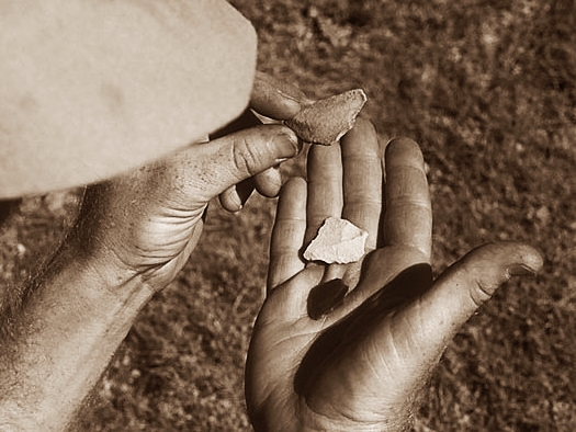
Worked flint from tepee rings.
The Oregon Trail was America’s great road west until completion of the transcontinental railroad. Thus, it was only fitting that we returned home on the train-– the Amtrak version of the Northern Pacific’s Empire Builder. We stood on the platform between the cars watching the west roll by in the sunset. We’d seen the elephant.
Shortly after this trip, I read letters written by my great-grandfather as a 19 year-old infantry private. He would have recognized most of the route we hiked. In the summer of 1867, he covered 1,700 miles of wagon trails, from North Platte, Nebraska, across Wyoming to the Utah line, then north to Soda Springs, back across the Wyoming Range and South Pass on the Oregon Trail to a fort just east of Casper. It was easy to imagine him there, and easier to feel I was living his life again.
Such travel is only possible at a human scale and tempo. Every one of those miles taught me volumes about myself and the meaning of determination, persistence, and downright stubbornness. At the same time, I learned about the innate decency of people, their uncommon generosity, and compassionate curiosity. It was a great lesson in what it means to be an American.

 customer satisfaction; they occurred spontaneously out of curiosity, mindful observation and personal interactions. So, go on tour, close by or far away, keep your mind clear, your eyes open, and you will be your own best guide.